The technology to see more.

The data and intelligence to help you see clearer using proven, leading edge technology.

The highest image quality with near zero impact.

Whether you need 2D, 3D or 4D, the extremely high resolution we can deliver makes the difference between discovery or disappointment. A clearer picture of what’s underground means you will discover more of the sub-surface without destroying the surface.

Traditional methods

Aerial view of a forested area with cleared sections, some patches snow-covered, and a grid of dirt roads.

Explor® methods

Aerial view of a dense green forest with trees of varying shades of green.

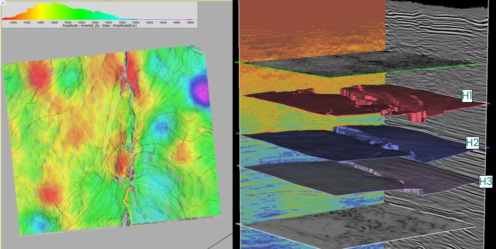
Typical results (left)

Legacy: Acquired in 2017

  • Multi vibrator array

  • Multiple sweeps per source point

  • Flip flop, central source control

  • Cabled system

  • Geophone arrays

  • Conventional survey / positioning

Seismic reflection profile showing layered underground formations with varying densities and faults, used in geological or oil exploration.

Explor® results (right)

Explor: Acquired in 2023

  • Single vibrator

  • Single sweep

  • Blended, autonomous acquisition

  • Nodal system

  • Point receiver

  • Real-time stakeless positioning

A detailed geological and topographic 3D map showing a terrain with colorful elevation data, contour lines, and stratified layers labeled H1, H2, and H3.

Explor® enables you to see clearer than ever before.

We can provide industry leading resolution at an affordable price.

A range of technology options to fit your needs.

Explor has the broadest array of source options in the onshore seismic industry.

A John Deere skid steer with tracks carrying weight drop seismic data acquisition technology operating on a snow-covered field under a cloudy sky.
A vibroseis vehicle is driving through a lush green field under a partly cloudy sky.
Inside an aircraft cargo area with luggage secured by straps.
Canadian seismic contractors driving in a forest-checked area marking a boundary or utility line with orange markers, with seismic data acquisition machinery and vehicles in the background.

Source technologies:

  • Led by our flagship AHV-IV PLS-364 vibrators.  Additionally, we have access to mini and shear-wave vibrators.

  • We can do everything from conventional deep-hole dynamite to advanced stakeless minihole work.  Explor has used charge sizes ranging from 56 grams to 50 kg. Explor is continually optimizing our methodologies and source configurations to integrate them with IntelliSeis.

  • Weight drop sources - this inexpensive, generally lower-bandwidth source is well suited to many applications, and can act as an agile infill source tool in many situations. We have built a proprietary baseplate, and we are adapting and improving the sensor technology for more robust time-break acquisition.

  • Our patented, proprietary electro-fluidic impulsive source is a game-changing solution for many emerging applications.

  • Our patented, proprietary single-person portable impulsive source is a game-changing solution to sensitive environmental zones.

  • Explor has many other source technologies we are testing and developing including small shear sources and a range of others.


Logo of Intelliseis with stylized red checkmark integrated into the text.

Our intelligent software that integrates and analyzes all data for quick and easy reference on an interactive dashboard. Explor customers can log in and get near real-time updates and analysis.

Explor® the leading edge of technology.

PinPoint®

Explor’s PinPoint® seismic source enables ultra-high density imaging while achieving a near-zero environmental footprint.

PinPoint logo with a red curved line and black text
Man wearing a white helmet, sunglasses, bright yellow jacket, and a backpack walking through tall grass or reeds.
Close-up of a seismic control panel with buttons and lights, being held by a person wearing gloves outdoors, with snow-covered grass in the background.
Aerial view of a vast landscape with dense green forest and patches of yellow and orange trees, under a partly cloudy sky.
Seismic contractors and engineers conducting a desert exploration or testing, using equipment attached to inflatable or balloon devices on sand dunes with a remote vehicle nearby and a team of onlookers observing.

Receiver nodes

Wireless nodes have opened the floodgates to innovative seismic solutions. No cut lines or strings attached.

Rows of Stryde nodes, stored in a display rack in a shop getting ready to be shipped out.
Stryde nodes in the dirt and snow on the ground.
A Canadian seismic contractors wearing a safety vest and helmet is standing in a wetland or marsh area, using a near zero footprint seismic data acquisition tool to examine the watery area, with trees and shrubs in the background.
A large stack of Stryde nodes arranged in a container, surrounding a work station with three computer monitors, and a device with multiple nodes on top.

LightSpeed

Explor is experimenting with advanced seismic pulse technology that will be even faster and more agile.

Small green and black tracked vehicle with a weight drop seismic data acquisition machine, on the side of a rural road next to a cornfield under a clear blue sky.
A small tracked vehicle with a blue and black color scheme, equipped with a seismic data acquisition machine, operating on a snow-covered trail in a forested area.
A John Deere skid steer with tracks carrying weight drop seismic data acquisition technology operating on a snow-covered field under a cloudy sky.
A crew working on a forest trail with a machine and safety markers, surrounded by trees with dry leaves on the ground.

IntelliSeis®

Our intelligent software that integrates and analyzes all data for quick and easy reference on an interactive dashboard.

Logo of Intelliseis with stylized red question mark and red slash
A digital map with network data visualization. The map displays various colored lines indicating deployed nodes and VPs, along with charts showing line lengths, nodes, and VPs counts across different locations. The interface includes a timeline, statistics, and legend, all overlaid on a satellite imagery background.
A map showing various data points, node retrievals, and metrics related to lighting and network nodes in Michigan. Overlay of nodes, grid lines, and data graphs at the bottom.

Explor® our full range of capabilities.

Explor has acquired every survey type across a broad range of industry verticals in all terrain types.

Fall landscape with yellow and orange trees, tall grass, and a dense forest of evergreen trees in the background.

Do you have a project in mind?

Discuss a unique or complex project with one of our team members.